Walking the Matiri Range from Thousand and Hundred Acre Plateaus to the Wangapeka had been on my list for years. This weekend the weather gods delivered (with a day of southerly to keep us honest) and we finally pulled off this fun route. It was an awesome mix of well-established trail, time wandering in the alpine zone, thick bush-bashing and negotiating countless little bluffs that don’t show up on a TOPO map.
On Friday morning we left one car at the Wangapeka road end and then drove up the Matiri Valley. I flagged down a ute and asked the guys in the front if one of them would be happy to drive my car back to Murchison. “Just leave it at the kayak school and put the keys on a wheel or under the doormat,” I said, as we started wandering up valley. All I knew what that he was called Hemi and he lived in Reefton. “This is the first time a stranger has given me their car keys.” he said with a big grin.
Day 1: Matiri roadend – Lake Matiri Hut – Poor Pete’s Hut – just short of Larrikin Creek Hut – The Haystack

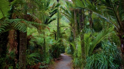
It was close to midday when we finally started meandering along the track by the Matiri River. The trail starts with some farmland and soon enters beech forest until you pop out at Lake Matiri Hut. Shortly after crossing Bay Creek, the trail climbs a steep spur through a diverse forest of silver and mountain beech, kamahi, rata and mountain totara. If you take the time to look down you find all sorts of magic on the forest floor, like these blue mushrooms that are endemic to New Zealand. You may recognise them from our $50 bank note. We’re the only country in the world with a mushroom on a banknote. The Kahurangi National Park is also home to half of New Zealand’s 40 carnivorous land snail species (Powelliphanta).
Reaching the plateau rim, we found ourselves in a huge expanse of tussock land dotted with patches of stunted forest. From here a marked route winds its way across the plateau to Poor Pete’s Hut before continuing through tussock and patches of bog towards Larrikin Creek Hut. We left the track around 1 kilometre before Larrikins and headed directly up the ridge to point 1526, The Haystack. It was easy going for off-track travel – a short section of bush-bashing followed by rocky scrambling to the summit.

Upon arrival at the top we were treated to epic views of bush-clad hills in all directions and we made a spontaneous decision to camp right on the summit. The ocean glimmered on the horizon as we drank tea in our sleeping bags, perched on a lump of limestone. Clouds swirled in and out, momentarily giving us glimpses of Hundred and Thousand Acre plateaus below.
Day 2: The Haystack – Hurricane Hut

Wind and rain battered our tent as we opened our eyes in the morning. A southerly had started to set in with increasing wind, rain and poor visibility. It was a good nudge to get along the range so we could retreat to the bush before things got too miserable. We had no views but enough visibility to weave our way along the ridge, negotiating lumpy tussocks, spaniards, chunks of limestone and the odd sinkhole. We continued along the Matiri Range to point 1326 before bush-bashing down to the Matiri Track a few kilometres short of Hurricane Hut. On a previous trip along this section of the range I had headed down earlier (near the saddle before 1326) – but I don’t recommend this. Quinn described this part of our wee mission well: “Wet, windy, and steep descent from The Haystack to Hurricane Hut including some classic full contact bush bashing travelling <1 km/h. Neither of us were keen on re-entering the tops (we had planned to continue towards Wangapeka Saddle in the afternoon) until the weather had passed so spent the afternoon in front of the fire and catching up on world news thanks to a surprisingly recent copy of Woman’s Day.”

Day 3: Hurricane Hut – Matiri Tops – Wangapeka Saddle
This section is a popular route amongst keen trampers. The tops can be accessed by a marked trail at both ends so there’s no bush-bashing. “A marked route climbs to point 1442 above Hurricane Hut. Beyond this point there are no markers. Most of the distance to the Wangapeka Saddle is above the bushline with only one tarn (north of point 1398) for a water stop. Panoramas of the Mokihinui and Wangapeka catchments and distant ranges of the Mt Owen massif, Mt Patriarch and Mt Kendal are superb.” – DOC.

For most of the tops there’s a well-worn trail with mellow tussock travel. As you get closer to Nugget Knob things become a bit more rugged and exposed. We opted to stick to the ridges but there are some sections where people may opt to skirt around a bit lower to avoid some exposure. You wouldn’t want to be up here in gnarly weather as some of the thinner ridges would get pretty dodgy in high winds and there are no great places to abort mission.
Once you hit the Wangapeka Saddle it’s a cruisy walk down to Stone Hut, where you’ve got two different route options: out via the Wangapeka Track or taking the route to Mount Luna and exiting via Kiwi Saddle Hut, Mount Patriarch and the Gibbs Track. We sat in Stone Hut pondering options, eventually deciding it would be cool to spend the next day mountain biking or whitewater kayaking to top off an awesome weekend. So we legged it out to the car. It got dark and we continued on with head torches. We left the Cecil Kings Historic Hut with a small handful of Easter eggs, the hut’s occupants lazing in front of the fire as we continued towards the road. The full moon rose and was reflected in the river, shimmering through the beech forest.
Interested in tackling this route yourself? For more information on the area, check DOC
Post by Dulkara Martig